About Me

My photo
Just a meandering soul sharing my backyard. Visit my Flickr page too! www.flickr.com/photos/meanderingwa/
Showing posts with label shrub steppe. Show all posts

Saturday, March 21, 2015

Happy First Day of Spring

Since it was bucketing down rain this morning I knew today was an Eastern Washington day.  I headed for the area east of Ellensburg beyond the wind farm.  It is here where I usually find blooming cactus.


This day gave proof as to why the wind farms are here.  The wind was really whipping and getting decent photos of trembling flowers was a challenge.

All the early flowers were here.

Sagebrush Violets
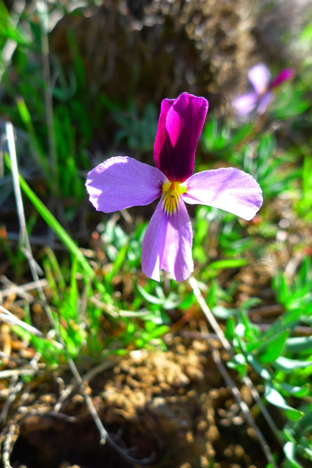


Bluebells snuggles low and protected around most anything.  These were next to an Elk skeleton


Yellow Bells are the flower most people mention when talking about the early Spring flower of the dry side.


Dagger-Pod only grew in the sheltered sunny hillside, well below the rough wind at the top.


Cushon Phlox is just coming on now.


The Hedgehog Cactus are just starting to make buds, so they are a week or two off.


I stopped at the Red Horse Diner for lunch and the sunny window, with no wind, was welcome.


When I come home via I-90 I usually get off at Preston and come via Fall City.  It may take a few extra minutes but it is more peaceful than the Bellevue corridor


Friday, February 24, 2012

W ~ White Bluffs, Hanford


It is odd to think of such a place of beauty at the backdoor of the Hanford Nuclear Reservation.  But it is the reservation which actually as the foundation of this lands beauty. 

The Hanford Reach National Monument was created as a buffer zone around the Hanford Reservation.  Along with the adjacent Yakima Military Range and the Hanford Reservation itself, it preserves a large swath of steppe, grassland and dessert.  From space the vegetation borders of these areas can easily be seen.  Recent news that the Arid Land Ecology unit west of Hanford was once again going to be open to hikers excites me very much.  I visited once with an Ornithology convention and the wonders we saw on our short visit made me want to return.

The area is given to very harsh extremes of weather and ecology.  Stunningly dry its large treeless areas can be a challenge in sunny weather.  Wind can be fierce and also draws moisture from you.  I never venture out into this area without 2 gallons of drinking water in the car.

The Columbia river cuts through the middle and it is here the river flows freely, unencumbered by the multitude of dams and their effects.  On the east side of the river thick chalk hills are cut and show their gleaming white face.

It is easy to ramble for hours along this cliff face.  In the Spring the ground is alive with flowers and bugs of all descriptions.  Bird congregate around rivers, streams and the pothole ponds and lakes that stud the area.  Much of the region to the north and east of here was carved by the Bretz Floods.  These floods left numerous ponds and lakes behind.  White Pelican and Sandhill Crane can be found along these waterways. 

http://www.fws.gov/hanfordreach/index.html

Wednesday, February 22, 2012

U ~ Um(p)tanum


Umptanum or Umtanum are both the same word.  Like many Native language words, the phonetic spellings of these non-written languages give rise to a lot of variation.

But the meaning is always clear, the word means Contentment.

It is said the ridges of this upland area was home to many native animals such as Pronghorn Antelope, Elk and Deer, Jack Rabbit and some Mountain Goat.  The canyons running to to the river basins were often mild and snow free.  It was here that native peoples could count on finding food species in harsh seasons and access to their grassy grazing areas in the Spring and Summer.

I spent many hours along the top of the plateau doing bluebird nest box census.  I also gathered nests for an Entomologist to study nest parasites.

Time and again I was drawn to this spot.  I had thought, through faulty reading, that this was an old stagecoach stop, but I have since learned that this was an old wheat ranch.  I met an elderly gentleman here who said he lived on this place during WWII.  To the east of this ridge the Yakima River has dug a great canyon and the hiking in and out of the canyons are not for the faint of heart.  Blazing sun in the season and persistent wind.

But great views, wonderful flora and fauna and wide horizons are the bonus.

Saturday, February 18, 2012

Q ~ Quilomene


The Quilomene is another one of my lovely lonesome places. This large , isolated wildlife management area supports very dry habitat and it is here I find cactus and other near desert flora. Butterflies can be quite numerous as the area supports many species of mustard, which many butterflies are attracted to. The rough roads are a challenge to drive, so hiking is required to visit and view the habitat.

This unit is between Ellensburg and Vantage along the old Hwy 10. You can enter through the back door via the Colockum Wildlife area. There are extensive wind turbines in place along this road and it is also possible to drive into the Wild Horse Wind Farm and access the land during the Spring Summer ( very hot) and Fall . The wind turbines give a clue, it is rarely still here. The wind can be persistant and makes camera work a challenge.

Watch out for ticks. This is the only place I have ever picked one up.

Saturday, February 11, 2012

K ~ Kittitas


Kittitas


Kittitas county , located on the east side of the Cascade slope is the heart of Washington state. Its ecology ranges from high mountain and conifer forests to sagebrush steppe and upland grasslands. In the heart of the county irrigation farming supports one of the best hay growing acreage in the United States.

To the north the county is dominated by the Stewart Range (Mt Stewart 9415 ft) and the geologically distinct Wenatchee Lobe. The plant life of this high altitude region is filled with diverse species found few other places in the world.

I have spent many hours exploring the county and I return to it over and over as I can drive 1 ½ hour from home and be in a place so high and quiet that the beat of my own heart is too noisy.

Quite a number of photos in this month’s project were taken in Kittitas. This photo is taken from Umtanum Road above Ellensberg. This high plateau is currently home to the L.T. Murray Wildlife Management Area . In the late 1800 and early 1900 this area was farmed and ranched for wheat.

Sunday, May 29, 2011

Kittitas County Ramble

Using Professor Mass' blog and YouTube pod cast I knew the only open weather for Saturday was going to be Kittitas. How lucky I am that the center of our state is one of my favorite places to explore.


I decided to go where I would. I knew that I was not going to be able to get back for some time and I knew I have missed some of the best of the far dry side. I got up super early to get on the road.


My first stop is one of my favorite places, Elk Heights. This spot along the freeway is where the pine forests and hills give way to the basalt flows and grasslands of the dry side. As always the wind was ripping here and its temperature reminded me that they are still skiing some places in the mountains. Brrr. But who can resist Balsamroot and lupins in the fields.


I took the surface road along the Thorp Prairie and got a close up look at some of the farms and houses that have clearly been here over 100 years. Behind this barn complex the land gives way to a deep cut in the basalt. This Hwy 10 road used to be the main east west highway through the state. The Thorp area and the land to the east through Ellensberg supports some of the best hay agriculture in the country. The hay here is rich and plentiful. It is also huge business. Much of the product gets placed directly into shipping containers and winds up in the best barns in the far Pacific Rim. The hay for the Sydney Olympics came from this valley.


By the time I got to Ellensberg I could see the wind turbines and noted that they were barely turning. I know they can choose to run them or not, but could I be in luck and have a calm day? If so I knew there is not time like now to get up to the Colockum Management Area along Hwy 10 and sleuth out some of the fun plants of the dry side.


There were several trucks and trailers with off-road vehicles. Over the way a lone woman appeared to be weeding or picking something. As I walked near I saw the cross I had noted before. She was cleaning bits from around it. Hand made, sprayed in Camo with name and date of one far too young. The woman could be his mother. I was reminded that this Memorial Day means there are outings missing some of the loved ones. I have to imagine this young man once roamed these hills on his motorcycle. She did not look up and I did not disturb her in her loving task.


The area was nicely quiet and with no wind I felt that my foot falls were making far too much sound. My binocular straps are on swivel clips that squeak and chirp. Sometimes they make me stop and wonder who is behind me.


But I could hear music. My Pavarotti! A Sage Thrasher sang his run-on song; on and on like an aria. Lovely warbling all over the scale, it always sounds ever so slightly rusty, as if he needs a drink.


I also heard a Western Meadowlark. The lone bird up on the slope acted like all Meadowlark when I am on foot. Flighty mistrusting and never willing to hold still. I don't know how I got so lucky to capture this one photo. I really had my lens zoomed up.


Birds never seem to be in the right position relative to sun light sky or background. That is what I thought would happen with this Loggerhead Shrike photo, but I am pleased to present him to you. This bird is also known as the " butcher bird". They capture bugs and impale them upon thorns and barbed wire spikes for safekeeping. His song is small , private chortles and chips.


Clearly all these birds have hopes for a happy nesting season.


I enjoyed being in a gully and looking up slope to see lovely big sky like this.


I hiked further north than usual and turned back to enjoy the ridge and how it changes as you go up slope and gain the top. This soil, in places is bare basalt rock and here I find Hedgehog Cactus.


Most of them are past bloom, others barely started ( like the above) , but I got lucky with this one. Bonus bugs too!


Dominating the ground here are the woolly-pod vetches / locoweeds (Astragalus) and Buckwheats (Eriogonum). These are an annoying array of plants that take tons of study to get to know. I am usually content to recognize them for what clan they belong to. The Buckwheats are favorite flowers of many of our butterflies. While the wind was not blowing I was not seeing much in the way of butterflies. I know they like to fly at certain times of day. Around here seeking out wet areas and mud pans is a great way to capture pictures. I kept hoping the clouds would break and warm the area enough, perhaps drawing the bugs out of hiding. Nothing ever happened.


I was content to wander up over the ridge looking for the prize I knew should be here. I was not disappointed. The Bitterroot are just coming into bloom and I found many. This will likely be my only chance for the year and once again, I know my love of this flower is justified.


Rediviva, reborn


The roots spring back to life when soaked in Spring rains and the succulent stems support the tough buds as they break out of the dry , crusty lithosoils.


I walked further east than usual and enjoyed the down slope of the ridge. Where the slop develops a pitch the soil gains moisture and the grasses start again. Here, looking east I can just make out the other side of the Columbia River and where the agriculture area starts again. To the South I can hear occasional sounds of artillery on the Yakima Firing Range. It echos and bounces over these hills.


Rock outcrops break the south slope of this ridge and I looked for Horned Toads and other surprises but found none. Just more flowers,


Brodiaea , Tritelia


Rock Penstemon


Phacelia


and the every challenging daisy clan. I believe these are Townsendia


I headed back along Hwy 10 to Ellensberg and noted not very far from the ridge the pavement was soaking wet. It had poured rain not a mile from where I was. I wandered the roads back to Ellensberg stopping to admire this old barn.


Some of the fields flood up at this time of year when tiny creeks burst in the flats and the flooded fields support Wild Iris.


So it was a lovely slow type day. I needed something relaxing and not too challenging. It has been an intense, fast, busy couple of weeks. Even though it is a three day weekend, busy stuff and work calls on Sunday. Monday weather promises to be not that great but we will have to deal with that when it arrives.


Today I said good-by )( or rather "thanks" ) to a traveling companion of the last few years. I never met her, but she was always with me on Sunday morning. Liane Hansen of NPR retired after 22 years of sharing Sunday Morning with us. I knew I could count on her to tell me something new and share The Puzzle with me. Her voice carried me along over many miles.


Have a lovely "retirement" Liane, you will be missed. I hope your new road is filled with many adventures and wonderful discoveries.


To you all, I say goodbye for a few weeks. I too am off on an adventure.


Someplace like here...only different.

Wednesday, April 21, 2010

Umtanum Ridge 1000 in 1

Contentment.

The meaning of the word Um(p)tanum is contentment

I took a day off from work and spent it hiking the Umtanum Ridge south of Ellensburg. This area is further east and south from the Ray Westburg trail and marks the eastern edge of the L T Murray Wildlife Management Area. The exciting aspect of these explorations is seeing how the distance of about 15-20 miles, as the Raven flies, presents a completely different ecology


The Umtanum Ridge forms the west wall of the Yakima River Canyon. The winding highway from Ellensburg to Yakima is often overlooked for the faster I-82 further east. The canyon skirts the west edge of the Yakima Firing Range, a large mixed military training area north of Yakima. These areas represent some of the largest preserved habitat in the state.


Here on the eastern edge of this basalt lobe, it is much drier and hotter in the season. The canyon is stunning with a twisting and turning highway that gives you in your face views of basalt walls. Up in the walls raptors of all kinds; hawks eagles falcons, nest in high concentration. You will also find Raven Turkey Vulture and Canyon Wrens.

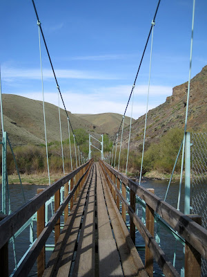
When I arrived early on what was expected to be a hot day I could hear a Canyon Wren calling from high in the walls. Umtanum Creek was running and I started along the trail watching for surprises. It didn't take long to find a bit of Prickly Pear Cactus. That was a surprise. The trails, which start at the end of this bridge over the Yakima River, are not well marked, the guide book warned me of this. I doubled back and soon found the track. It skirted along a steep wall to the left and I made my way up hill following a trickling creek.


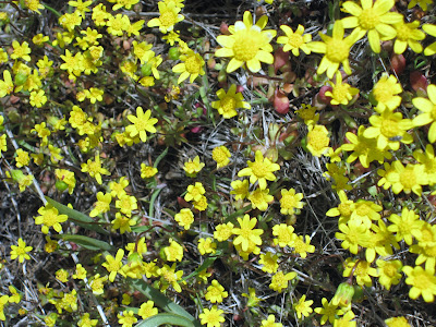
It was interesting to see how each steep up slope held little in the way of plants aside from the rabbit brush, sage and grasses. When a somewhat level area was reached a community of flowers would present themselves. The overwhelming numbers of Gold Star was something to see. Higher up I could look over to the next hill and clearly seen a light wash of yellow as it too was carpeted with these little yellow gems. They have quickly become a favorite of mine.


I found many of the flowers here smaller and more "stunted" appearing than those found in other environments. They also appear to be a bit behind in the bloom cycle. The elevation here is higher and drier. I suspect that Spring is just getting underway. The Gold Star and violets dominate.


I found some Brodiaea here. Those at Catherine Creek, already well opened, colored white with blue stripes. Here they are still closed and the solid dark blue mentioned in my field guides.

There were a lot of Phlox many of them tucked under shading rabbit brush and sage.


Lupins are just getting into their bloom.


The climb was unrelenting. This is a 1000 in 1, you gain 1000 feet elevation for every mile. The round trip to the top of the ridge along the ridge and back is six miles, so a pretty good work out . It is the type need to do at least a couple times a month if I can. This one served to remind me that I am still not content with my hiking shoes. This was the first serious downhill trial and they did not perform well.

The views from here are wonderful. You can almost imagine no civilization but from half way up the ridge you can see the distant ribbon of I-82 and occasional radar and other towers on ridge tops. That is I-82 tracking left to right through the center of the landscape.


I was thrilled to have the area to myself. Local residents were all around. Western Meadowlarks sang all over. They are so shy but I saw plenty of exuberant display flights where the males fly and sing to impress.

A Raven really put on a show and I was not sure if he was trying to impress another bird or perhaps show me how tough he was. He made one pass making a sound like I never heard before. He almost sounded like a grouse or pheasant and was undulating and gliding in a very unusual fashion. He circled back and began to torpedo and make swooping barrel rolls. It really seemed that he did it just because he could. After the barrel roll display he flew off and I never saw another Raven the rest of the day.


I had a wonderful close encounter with a Gopher Snake. This was the first time I ever met this snake and made very sure its pattern was laid out appropriately for the safe Gopher Snake as opposed to the more exciting Western Rattlesnake. Thoses are Gold Star flowers.
You are looking at the flowers, aren't you?


Reaching the top of the ridge I saw yet another smaller hill to climb. The road that crossed top of the ridge line serves as the "you are done" marker. But that little hill promised a possible view of Mt Adams and Mt Rainer, so up I went.


I am so glad I did. I found Hedgehog Cactus, another first find. These are rare now and on the state "Sensitive Plant" list so I had to be very careful where I stepped. These were so well camouflaged in the soil and soon I found one, then another. They are already setting buds and will bloom later in May. That will be something to see.


The trip down, as expected, was so much faster than the trip up. I am so happy to have explored this area of the trail and need to get back and follow the trail at tracks along Umtanum Creek to the waterfalls. I have been to the waterfall from the upland side. It is a favorite little area of the road I use to patrol monitoring bluebird boxes. I never visited from the downriver approach. I want to see what is around that bend and where this green area goes.


I felt like I had been on a foreign journey to a very new type environment. A wonderful five hour workout produced some new first sights and a feeling of relaxation.
Well from the ankles up.


I need new shoes

Tuesday, April 20, 2010

Ray Westburg trail, Thorp

I returned to this trail for the first time this year. I heard about it in an article in the Seattle Times and thought it was just perfect for a day away.


Thorp is located at exit 101 on I-90 just west of Ellensberg. Most people know it for the gigantic "fruit" stand. Surrounded by hay fields this is the place where the foothills meet the flats. From here one can strike out into the foothills leading up into the L.T. Murray Wildlife Management Area and the National Forest areas that lead up to the Cascades.


I love the area since the ecology is so dramatically different from my everyday world that if fells like I have gone someplace foreign even though I am well familiar with this backyard.


The canyon roads leading up to the L T Murray are often only walkable. Those with horses have great opportunity to get far up and in. If you have the right road you can often drive up but there can be wash outs and rock fall. These events actually help keep the area wild and clean.


The Ray Westburg is a popular hiking and running trail. Named in memory of a local high school coach it attracts people of all abilities. The climb is moderately steep with great sweeping views of the Kittitas Valley and the Stewart Range. One local told me that it is a popular summer night hike since the horizon is clear to the east, a great place to watch moonrise.

The environment is great. Sage and Rabbit Brush dominate. You get into the dry ecology and are surrounded by plants. Last summer there was a lot of buckwheat in bloom. This was a huge bonus as buckwheat supports a whole population of butterflies who dine on them. It provided a lot of camera fun.


In late June Desert Mariposa Lily are everywhere in the middle third of the trail. They are a beautiful surprise for anyone expecting a lifeless place. You all will have to wait for June to see pictures.

To the west of the trail a re-entrant (short valley) supports pine trees and as you climb you can see into the branches. A few snags are mixed in. Last year I saw a Lewis Woodpecker nest and a group of young Kestrel waiting for their parents.

Sunday I arrived a bit later than I thought I would. Work took longer than I thought it would. I like to get to an area early for the best birds and to beat the heat. I don't know what I was thinking. I knew it would be warm so I brought a short sleeve shirt. I even remembered my water bottle and my car now has its required gallon water jug. so I always have refills.
At the beginning of the trail is a private property. There is a large vegetable garden just getting started and next to that a nice line of cherry trees. It was here that I photographed the House Wren that I use for my avatar.


When you get to the start of the trail proper you find one of the most welcoming sights going, a walking stick rack. People bring and leave stout sticks or even ski poles and leave them for others. This is a trail I would recommend a walking stick for sure. You can see the ecology of the slope andhow it changed from the garden plot.


The way is a good consistent up. There are plenty of reasons to stop and look


flowers...
Yellow bells, the early Spring bloom. Spring is just starting on this slope.


Sagebrush Violets and Gold Star, carpets of them, particularly on the flat top. Another group of flowers that signal Spring.
Daggerpod. These leaves are soft like lambswool.
bugs...
Don't know what these buffy green bugs are, but they are everywhere, here on Spring Beauty.


even an occasional horned toad. They love ants.


and the view.
To my horse buddies, that is Timothy hay yumm

At the top there are some loving memorials to community members. If you ramble on you will find the roads and habitat of the L T Murray. This is an open flat dry spot and it is a bit of a contrast to the ecology of the slope. It is possible to drive in to this spot , but there is something more satisfying about the hike.


You can go down the way you came up or, like I did, detour onto the Boy Scout Trail. This trail cuts left and descends in the next re-entrant. Unlike the open slope of the up trail, this trail goes through pine woods. Right now there is not a lot of plant and flower action in the woods. I did get a nice visit from a Pine Chipmunk and watched a nuthatch excavating a nest hole.


I discovered a new plant along the irrigation channel that returns to the trail head, Columbian Piccoon. It is juicy leaved and packed with flowers. Plus the name is odd, my book mentions no meaning of the name.
bug butt


The round trip can take a few hours if you are a meadering one, like myself, or just an hours or so if you are a runner, like those you might encounter very early in the morning.
My car now needs one more essential for this time of year. Sunscreen. We now need sunscreen.