About Me

My photo
Just a meandering soul sharing my backyard. Visit my Flickr page too! www.flickr.com/photos/meanderingwa/

Thursday, April 29, 2010

Arbor Day, 2010


WAITING FOR A MESSAGE


Rochelle Mass

Trees help you see slices of sky between branches.


point to things you could never reach.

Trees help you watch the growing happen,


Watch blossoms burst then die,


See shade twist to the pace of the sun,


Birds tear at unwilling seeds.


Trees take the eye to where it is,

to where it was,

then over to distant hills,


Faraway to other places and times,

long ago.


A tree is a lens,

a viewfinder, a window .

I wait below


for a message

of what is yet to come.

Wednesday, April 28, 2010

Another Experience to Tick Off

Monday I spent the day with three other members of the Native Plant Society. We left Issaquah at 8am and traveled to the Vantage area. The planned activity was to study the plants of the Sage steppe.


I am a rank beginner when it comes to this level of "botanizing" Plants are discussed but common names are not used. The taxonomy names are used. To my ear they sound incomprehensible, even though I know and use words like them daily. Having learned "buckwheat" "desert parsley" " Milk-vetch" it was difficult to be nimble with Eriogonium , Lomatium and Astragalus. Those are just the Genus names, each one has several species attached and in some places distinct sub-species.


But everyone one was nice and we each had our own area of interest. The leader of this trip was more welcoming and supportive than the previous trip I experienced. I think the smaller group was a huge plus.


The weather was perfect, overcast with almost no wind. The Columbia River and the areas surrounding it, particularly west towards the Cascades, are known for their persistent winds. Wind farms are springing up. This is the Wild Horse Project. One of the trip members told me that they have a nice visitors center. I asked her if they allowed people to ramble the property and visit the environment. She was not able to really answer that so I might have to pay a visit and find out for myself. I can imagine that they would not like people near their equipment but it does look like a way to get into this difficult area.


Our first stop was at the Quilomene Wildlife Refuge. I have never explored this area beyond the small patch we visited this day. The roads are usable only with a solid , high clearance 4WD vehicle. We climbed slope of this south facing canyon and slowly explored the plants along the way.


For me it is about appreciating the change of plants and their community in this small environment. The average plant community is dominated by rabbit brush , bitter brush and other sage plants. Hard woody and somewhat dangerous in a thorny way. Smaller plants and flowers often grow tucked inside, using shade and conserving evaporation.


When we reached a steeper bit of slope, the soil gave way to more rocky ground. The plants changed and it was here that the Snowball Cactus were everywhere. Many of them were in flower. Our leaders commented here that the flowers were more open on their previous visit, a windy sunny day. It was early and overcast so the full bloom was lacking, What I saw, however was perfectly wonderful.


At the very top of the hill we had a further change in the soil and there were more grasses and delicate greenery. Violets and Spring beauty could be found. We found a large slope of Large-headed clover. These were by far the largest blooms of this plant I have ever seen and certainly the largest numbers of them.


Three hours on this slope passed far too quickly. We drove to the end of the road at the Ginko SP Headquarters. I have not been here in some time and was thrilled to see that the facility has all new signs and everything has been cleaned up. This site is a great place to take a rest break on a long cross-state journey. You have a great look at the stunning walls above the Columbia River and learn a bit about the floods that formed the area.
The nearby Petrified Forest is another good place for a ramble. It is a large open slope and in the summer there is no shelter from the persistent sun, so arrive early. There were many very large petrified logs though none with identifying signs. I was struck by the beautiful blue streaks in this one.


We went south along the river to the foot of Sentinel Gap and explored the first of two sandy soil sites. There was an abundance of Larkspur and Brodiaea (the blue type) blooming here. There are several types of Asters as well as an abundance of Lupin. These are low growing and more unassuming than you see in the wet meadows around Mt Rainier. All perfectly understandable given the hard living conditions. High wind, low moisture a lot of sunlight and heat.


We crossed over the river and I knew that the potential highlight of the day was next. Sand and dune ecology is found here in the along the east side of the Columbia. The area I visited near Hanford, White Cliffs is a good example. I knew some of the valleys leading away from the river held dunes. All of these canyons and valleys were part of the great Bretz floods which formed the landscape of the majority of the eastern basin ~10000 years ago.


I did not expect that the stop would come so soon. We pulled over on the side of the road in a place I had passed many times. I always thought of this as a spot where truckers could have a safe place to pull off the road. I never realized that there was a "day use only" spot leading down slope nearer the river. We scrabbled through a barbed wire fence and had yet another different environment, sand on bare basalt rock.


There were many of the foundation plants but also some new delights. Here wild onion suffered to grow only three inches high. By the time they put out a bloom, their leaves were usually gone.


Narrow-leafed Phacelia grew in many places as a single stem and blossom, here I found several that produced wonderful bouquets.


The highlight of the trip, a Sand Dune Penstemon already starting to fade. The leader was at this site only five days previous and noted the flowers that were failing. A stunning bit of beauty in an area many might feel has nothing to offer.


I could have stayed out longer and kept rolling on but it was already 5:00 and we faced 2 1/2 hours drive home. It was nice to be able to watch the landscape go by, the luxury of someone else driving. I had a great talk with another member of the group and it felt like in no time we were back at REI in Issaquah. I grabbed the opportunity to go in, wearing my hiking shoes and my feet and their end of day condition to buy a new pair of hiking shoes.


I now own a pair of size 10 1/2 hiking shoes. Somehow that "1/2" makes me feel like I have REALLY big feet, not just big feet. That darned second toe on the left foot is the one to blame.


So home to post one quick photo for my 365 project. There was no way I could bring myself to puzzle over the photos and plant ID's nor to write a scintillating blog entry.


While working on my Flickr entry I felt something on my arm and there it was... A tick walking up my arm.

My first TICK. All these years of tromping about in the eastern Washington area I had never encountered a tick. Now, 48 hours later, my skin has almost stopped crawling and every wisp of hair or stray thread is not a voracious arachnid threatening to lock into a vein.

Thursday, April 22, 2010

Happy Earth Day

Yesterday was the Birthday of John Muir. To celebrate Earth Day here are some of my favorite pictures from the last year and some quotes from Mr Muir.


"Who wouldn't be a mountaineer! Up here all the worlds prizes seem nothing."


"Everybody needs beauty as well as bread"


"In every walk with nature one receives more than one seeks."


"The power of imagination makes us infinite."


"Earth has no sorrow the Earth cannot heal."


"There is a love of wild nature in everybody, an ancient mother-love showing itself whether recognized or no, and however covered by cares and duties.


We never know where we must go or what guides we are to get...


Wednesday, April 21, 2010

Umtanum Ridge 1000 in 1

Contentment.

The meaning of the word Um(p)tanum is contentment

I took a day off from work and spent it hiking the Umtanum Ridge south of Ellensburg. This area is further east and south from the Ray Westburg trail and marks the eastern edge of the L T Murray Wildlife Management Area. The exciting aspect of these explorations is seeing how the distance of about 15-20 miles, as the Raven flies, presents a completely different ecology


The Umtanum Ridge forms the west wall of the Yakima River Canyon. The winding highway from Ellensburg to Yakima is often overlooked for the faster I-82 further east. The canyon skirts the west edge of the Yakima Firing Range, a large mixed military training area north of Yakima. These areas represent some of the largest preserved habitat in the state.


Here on the eastern edge of this basalt lobe, it is much drier and hotter in the season. The canyon is stunning with a twisting and turning highway that gives you in your face views of basalt walls. Up in the walls raptors of all kinds; hawks eagles falcons, nest in high concentration. You will also find Raven Turkey Vulture and Canyon Wrens.

When I arrived early on what was expected to be a hot day I could hear a Canyon Wren calling from high in the walls. Umtanum Creek was running and I started along the trail watching for surprises. It didn't take long to find a bit of Prickly Pear Cactus. That was a surprise. The trails, which start at the end of this bridge over the Yakima River, are not well marked, the guide book warned me of this. I doubled back and soon found the track. It skirted along a steep wall to the left and I made my way up hill following a trickling creek.


It was interesting to see how each steep up slope held little in the way of plants aside from the rabbit brush, sage and grasses. When a somewhat level area was reached a community of flowers would present themselves. The overwhelming numbers of Gold Star was something to see. Higher up I could look over to the next hill and clearly seen a light wash of yellow as it too was carpeted with these little yellow gems. They have quickly become a favorite of mine.


I found many of the flowers here smaller and more "stunted" appearing than those found in other environments. They also appear to be a bit behind in the bloom cycle. The elevation here is higher and drier. I suspect that Spring is just getting underway. The Gold Star and violets dominate.


I found some Brodiaea here. Those at Catherine Creek, already well opened, colored white with blue stripes. Here they are still closed and the solid dark blue mentioned in my field guides.

There were a lot of Phlox many of them tucked under shading rabbit brush and sage.


Lupins are just getting into their bloom.


The climb was unrelenting. This is a 1000 in 1, you gain 1000 feet elevation for every mile. The round trip to the top of the ridge along the ridge and back is six miles, so a pretty good work out . It is the type need to do at least a couple times a month if I can. This one served to remind me that I am still not content with my hiking shoes. This was the first serious downhill trial and they did not perform well.

The views from here are wonderful. You can almost imagine no civilization but from half way up the ridge you can see the distant ribbon of I-82 and occasional radar and other towers on ridge tops. That is I-82 tracking left to right through the center of the landscape.


I was thrilled to have the area to myself. Local residents were all around. Western Meadowlarks sang all over. They are so shy but I saw plenty of exuberant display flights where the males fly and sing to impress.

A Raven really put on a show and I was not sure if he was trying to impress another bird or perhaps show me how tough he was. He made one pass making a sound like I never heard before. He almost sounded like a grouse or pheasant and was undulating and gliding in a very unusual fashion. He circled back and began to torpedo and make swooping barrel rolls. It really seemed that he did it just because he could. After the barrel roll display he flew off and I never saw another Raven the rest of the day.


I had a wonderful close encounter with a Gopher Snake. This was the first time I ever met this snake and made very sure its pattern was laid out appropriately for the safe Gopher Snake as opposed to the more exciting Western Rattlesnake. Thoses are Gold Star flowers.
You are looking at the flowers, aren't you?


Reaching the top of the ridge I saw yet another smaller hill to climb. The road that crossed top of the ridge line serves as the "you are done" marker. But that little hill promised a possible view of Mt Adams and Mt Rainer, so up I went.


I am so glad I did. I found Hedgehog Cactus, another first find. These are rare now and on the state "Sensitive Plant" list so I had to be very careful where I stepped. These were so well camouflaged in the soil and soon I found one, then another. They are already setting buds and will bloom later in May. That will be something to see.


The trip down, as expected, was so much faster than the trip up. I am so happy to have explored this area of the trail and need to get back and follow the trail at tracks along Umtanum Creek to the waterfalls. I have been to the waterfall from the upland side. It is a favorite little area of the road I use to patrol monitoring bluebird boxes. I never visited from the downriver approach. I want to see what is around that bend and where this green area goes.


I felt like I had been on a foreign journey to a very new type environment. A wonderful five hour workout produced some new first sights and a feeling of relaxation.
Well from the ankles up.


I need new shoes

Tuesday, April 20, 2010

Ray Westburg trail, Thorp

I returned to this trail for the first time this year. I heard about it in an article in the Seattle Times and thought it was just perfect for a day away.


Thorp is located at exit 101 on I-90 just west of Ellensberg. Most people know it for the gigantic "fruit" stand. Surrounded by hay fields this is the place where the foothills meet the flats. From here one can strike out into the foothills leading up into the L.T. Murray Wildlife Management Area and the National Forest areas that lead up to the Cascades.


I love the area since the ecology is so dramatically different from my everyday world that if fells like I have gone someplace foreign even though I am well familiar with this backyard.


The canyon roads leading up to the L T Murray are often only walkable. Those with horses have great opportunity to get far up and in. If you have the right road you can often drive up but there can be wash outs and rock fall. These events actually help keep the area wild and clean.


The Ray Westburg is a popular hiking and running trail. Named in memory of a local high school coach it attracts people of all abilities. The climb is moderately steep with great sweeping views of the Kittitas Valley and the Stewart Range. One local told me that it is a popular summer night hike since the horizon is clear to the east, a great place to watch moonrise.

The environment is great. Sage and Rabbit Brush dominate. You get into the dry ecology and are surrounded by plants. Last summer there was a lot of buckwheat in bloom. This was a huge bonus as buckwheat supports a whole population of butterflies who dine on them. It provided a lot of camera fun.


In late June Desert Mariposa Lily are everywhere in the middle third of the trail. They are a beautiful surprise for anyone expecting a lifeless place. You all will have to wait for June to see pictures.

To the west of the trail a re-entrant (short valley) supports pine trees and as you climb you can see into the branches. A few snags are mixed in. Last year I saw a Lewis Woodpecker nest and a group of young Kestrel waiting for their parents.

Sunday I arrived a bit later than I thought I would. Work took longer than I thought it would. I like to get to an area early for the best birds and to beat the heat. I don't know what I was thinking. I knew it would be warm so I brought a short sleeve shirt. I even remembered my water bottle and my car now has its required gallon water jug. so I always have refills.
At the beginning of the trail is a private property. There is a large vegetable garden just getting started and next to that a nice line of cherry trees. It was here that I photographed the House Wren that I use for my avatar.


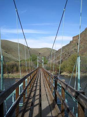
When you get to the start of the trail proper you find one of the most welcoming sights going, a walking stick rack. People bring and leave stout sticks or even ski poles and leave them for others. This is a trail I would recommend a walking stick for sure. You can see the ecology of the slope andhow it changed from the garden plot.


The way is a good consistent up. There are plenty of reasons to stop and look


flowers...
Yellow bells, the early Spring bloom. Spring is just starting on this slope.


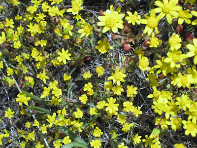
Sagebrush Violets and Gold Star, carpets of them, particularly on the flat top. Another group of flowers that signal Spring.
Daggerpod. These leaves are soft like lambswool.
bugs...
Don't know what these buffy green bugs are, but they are everywhere, here on Spring Beauty.


even an occasional horned toad. They love ants.


and the view.
To my horse buddies, that is Timothy hay yumm

At the top there are some loving memorials to community members. If you ramble on you will find the roads and habitat of the L T Murray. This is an open flat dry spot and it is a bit of a contrast to the ecology of the slope. It is possible to drive in to this spot , but there is something more satisfying about the hike.


You can go down the way you came up or, like I did, detour onto the Boy Scout Trail. This trail cuts left and descends in the next re-entrant. Unlike the open slope of the up trail, this trail goes through pine woods. Right now there is not a lot of plant and flower action in the woods. I did get a nice visit from a Pine Chipmunk and watched a nuthatch excavating a nest hole.


I discovered a new plant along the irrigation channel that returns to the trail head, Columbian Piccoon. It is juicy leaved and packed with flowers. Plus the name is odd, my book mentions no meaning of the name.
bug butt


The round trip can take a few hours if you are a meadering one, like myself, or just an hours or so if you are a runner, like those you might encounter very early in the morning.
My car now needs one more essential for this time of year. Sunscreen. We now need sunscreen.

Sunday, April 11, 2010

Catherine Creek, a beautiful blue day

Finding time to escape on the weekends seems to get waylaid by bad weather or the "needs of the many" at work.


Yesterday I escaped to a long delayed visit to Catherine Creek. This area first came to my attention via Flickr. A member had posted a photo of a wildflower the likes of which I have never seen.


Catherine Creek is located between the towns of Lyle and Bingen on the Columbia River. It is part of the Columbia River Gorge National Scenic Area.


I hit the road super early. The drive is long and I knew I-5 was closed down to one lane at Olympia. The weather, however was spectacular. It was nice to see the sun rise and the weather was crystal clear all day.


Driving east on Hwy 14 is a bit of an adventure. Once I got outside of Vancouver, I experienced the winds the Gorge is famous for. The two lane highway is full of bends and twists and very soon you start climbing to the Cascades. While the mountains are not as high here owing to the effect of the river upon the geology, higher mountains are very near and snow is present in many bare areas. Across the river you can see waterfall after waterfall. The drive from Portland to Hood River is famous for the number of waterfalls. Unlike the Washington side, the Oregon side of the river supports and Interstate which is fast level and an easy option for those in a hurry.


At the highest point of the climb I pulled off at a place called "Cape Horn" to take in the view. Well named, the winds were howling and the trees whipping to the west.


Off in the distance I could see Beacon Rock , a basalt monolith that sits right in the river. It is a famous hike and climb site. There have been Peregrine Falcons nesting here in the past and sometimes the access to the climbs are restricted. You can see Beacon Rock just to the center below.


In a very short time you can tell you are in "eastern" Washington. Pine trees show up in the woods and balsamroot flowers dot the roadside. In Bingen the hills look nothing like one sees in western Washington.


Indeed the whole of this area is a geology wonder. The Columbia River, with its power and age as cut a typical river canyon. Much of this is lost now that the river impounds behind dams and runs much slower and deeper than when Lewis and Clark floated through. One can find evidence of the catastrophic Bretz Floods of 10000 years ago. These floods carved and formed the geography of eastern Washington. Notice how the rolling hill suddenly is lost to a carved out rock face.


Smoothly descending hills abruptly become cliffs. River valleys end and become sharp waterfalls. Hanging valleys were key in Bretz's evidence of catastrophic erosion of the gorge.


Catherine Creek has a paved trail system that allows visitors of all abilities a chance to experience the native plants. There are also wonderful benches that permit sitting and enjoyment of the sweeping views of the river,


and the small but stunning waterfalls of Catherine Creek. The basalt walls of the little mini-canyon were filled with flowers and plants that would be the envy of any rock gardener. A perfect picnic spot.


I will say however, for the best flowers one should climb and ramble in the area across the road. There were many groups of folks present. Hikers and photographers. A group of students from an Oregon college and many people with dogs.


The footing was a challenge as the soil is thin and basalt rock footing is sharp and often loose. Many areas were seeping wet rather than forming runoff channels or soaking in. There was a lot of grasses and mosses and often the moss growing directly over rock made for tricky footing.

The area supports a mix of pine trees and oak trees. Oak is a rare tree in the state and this area around Lyle supports some ( if not the only) Acorn Woodpeckers in Washington.


It was wonderful to be able to ramble the informal hiking trail and I had some great views of the geology of the river area. Mt Hood gradually appeared through burning off haze.


I didn't encounter many people once away from the parking lot. I had a chance encounter with a skunk, my first "live" viewing. It did not stick around for a photo-op. I also saw a Blue-tailed Skink who had the same opinion on having a photo taken.


But these bugs were very obliging. There is no better opportunity for bug photos than the balsamroot , buckwheats and agoseris of eastern Washington.


I did not have a map so without knowledge of the trail length or timing, decided to cut across country and follow a power line back down to the highway. Along this route I found two samples of the unique plant that brought me here ; Grand Hound's Tongue. It was another one of those lucky hits simply because I decided to ramble downhill where I did.


The clustered buds open to become this


Blue also dominated the landscape with fields of Camas. Shooting Stars were everywhere and they were mixed with Death Camas. Upland Larkspur were quite thick and in many places associated with the Oak trees.


I found some Brodiaea, a new flower to learn. I loved the detail of the pale blue stripe. This flower can be found in a dark blue form, depending on the quality of the soil it grows in.


I wish I could have had time for an overnight and a chance to fully explore this lovely area. Klickitat County is said to have the most diverse plant life in the state. It is easy to see that this is possible due to the meeting of east and west, wet and dry low and high altitude.