About Me

My photo
Just a meandering soul sharing my backyard. Visit my Flickr page too! www.flickr.com/photos/meanderingwa/

Sunday, September 27, 2009

Kendall Katwalk, the last alpine hike of the year

Glorious weather means it is the last chance to get out and get up in elevation. Kendall Katwalk is a wonderful hike north from the Snoqualmie Pass ski area along the Pacific Crest trail. I got up there early since the 11 mile round trip carries 2700 feet of gain going in to the 5400 foot level.


There was a long gradual climb of switchbacks through the forest. Plenty of mushrooms all over. Even though I was on the trail by 845, there were already some folks coming down. One couple had a sack of mushrooms. I know I will have to brush up on safe picking for next season. This little fellow caught my eye. Yes he is purple!


Sometimes it is nice hiking a popular trail. I had some nice chats with folks and received scouting reports about blueberries! There were many fruiting plants all over. Mountain Ash was particularly abundant and a large flock of Robins gave away that they had been eating on the berries. They were plenty drunk on the fermented fruit and swooped and bickered in a very uncharacteristic fashion. A sure sign of Fall.


The Katwalk is well known for its wildflower fields. They are past now but I can see how they will be glorious after next years snow melt. I found a mystery flower that I will ask the gang on Flickr Washington Wildflower group. Yes it was a blue sky day.


I did find some Pearly Everlasting, which is always a fun photography subject


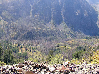
There are some pretty exciting parts on the trail with a drop off that is hard to appreciate on film


At the top of the ridge, on the north face of the nose I found this. I was thankful for my long sleeve jacket. It will not be melting off anytime soon as I heard snow level reports for 4000 feet in the next few days.


I had lunch on a chilly outcrop with a spectacular view. Unfortunately in the full sun, the photos are not the best and just don't do justice to the slope down into the basin.


The colors are slowly changing and the Vine Maple make and elegant picture here.


The most vibrant and welcome bit of color are the blueberry bushes. The leaves blaze red in the full sun. There are several different species here, each with their own distinctive flavor size and color. I sampled some that tasted like they had fermented and others were just right. Some are a bit tart and give nice contrast. There were little ones and big juicy ones. I found a wonderful spot thanks to some folks who got off on a wrong trail. I saved room in my water bottle to collect at their discovered spot and I was not sorry. Look at these wonderful colors and notice how plump these beauties are.


Need I say more???


Saturday, September 26, 2009

Forest Floor Ramble


Today was one of those days that I really needed to stick close to home and get fiddly bits done. I stopped by Redmond Watershed Park again. It is handy on my way back from the barn and early in the morning you can feel like you almost have the whole place to yourself. I am not a fan of graffiti but the note on newly placed bench, deep in the woods seems a bit more tolerable than most. The nice bench, made from logs, was welcoming, but I had places to be.

Usually I am looking up and out, but today there were so many things to notice on the forest floor. Right now mushrooms are everywhere. I have almost zero clue as to what mushrooms are what , but I certainly enjoy seeing and noticing their many colors, shapes and how they fit in the habitat. So many were pushing up through leaf and ferns. The edges on many trails were lined with them.

This one almost looks like Chanterelle, I believe it is Woody Chanterelle, but I am not confident enough and consider the cost in the store a reasonable price to pay for safety, at least for now.

These reminded me of marzipan mushrooms, but I guarantee you, that is NOT chocolate filling. It was soft and wet...but not chocolate

It is easy to see where some illustrators and animators get their ideas, when it comes to mushrooms


Fungi play an important role in forest ecology. Their hyphae (underground structures) break down deadwood, recycling the nutrients. They also serve a helper role in forest metabolism and many conifer trees cannot exist without mycorrhizae interface in their root systems. Of course many animals, from the smallest bugs to large hikers eat the mushroom. It is a pretty big industry and wild mushroom turf wars are known in Oregon.


Not everything worth noting now is on the ground. Year round it is fern paradise. I particularly like Licorice Fern. They often grow from moss on tree trunks and their rhizomes, when chewed, do taste like anise / licorice. They were used for cough and sore throat.


This wasp nest caught my eye, I almost waved it off as another mushroom


The sun finally broke an hour into my walk and it adds great dimension to our woods. This was a lucky find. I would not have been able to make the capture without the help of sunlight.


Elegant mosses and Sword fern


This Big Leaf Maple leaf looks like it fell right out of 1969. Pretty groovy, isn't it?


And this mushroom...I suspect some might think it pretty groovy too...


I'm not going to try it. You try it!

Lets get Mikey.


I spotted this bug and had fun sneaking in on it while it had a snack. It was not until I got home and got it in to the computer that he had a bug buddy on the upper deck. So many bugs and little critters nosh on these mushrooms that it will not be long before many of them and chewed to bits. The Douglas Squirrels are hanging theirs to dry and all over, pasta and omelette's are on the dinner menu of knowledgeable foragers.
My little ramble turned into 3 1/2 hours and 5+ miles.
Still got everything done

Monday, September 21, 2009

Welcome Fall

I came across this article in the Seattle Times this morning and thought I would pass it on. I visited Lincoln county during my Labor Day Rock and Road trip. Who knows, perhaps one of the wheat farms I passed through is part of this article.


I think it is a wonderful concept and certainly it brings the farmers a bit more profit.

But simply posting an interesting article seems a bit dull. One of my "fans" noted the absence of a "meandering post" this weekend. I was on call and running about with weekend chores. I just could not get myself away into the woods.

But ahhh tonight.. how better to salute the beginning of Fall than with a quick walk in the woods. Balmy weather is so typical for Puget Sound in late September. Our first day of Fall will prove to be a blazing hot time with forecast daytime in the middle 80's. It seems to easily cool off over night. Simply does not get better.

I stopped by Redmond Watershed Park on my way to the barn and was greeted by what is a subtle sign of the progression of the seasons. Just a few months ago it stayed light until nearly 10 PM now, not so much.

The woods already felt cool and dark. I could find many subtle signs that the Fall is here. Everywhere mushrooms are showing up. Douglas Squirrels will soon be harvesting and hanging them in trees. I know there can be some great finds for human consumption but I have never been brave enough to learn anything but the most obvious of the safe mushrooms.


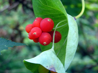
Bushes set berries and they are usually gobbled up by birds. In the Fall it is not unusual to find flocks of drunk Robins hanging about in (and from) trees from overeating fermented fruit. Ash and Madrone are particularly popular. I was thrilled to find these berries. I have never seen our native Orange Honeysuckle , Lonicera ciliosa in fruit. Usually the plants are growing up in trees, so challenging to spot. The flowers are eagerly eaten by birds and small mammals. They will pull off the tube flower and eat the base where the sweet nectar is collected. This honeysuckle plant was right at eye level.


There were Nootka Rose, Rosa nutkana still blooming in a few places. Such a wonderful deep scent. They have large hips (which is perhaps why I like them) and these will serve up tasty eating for many birds and mammals through the winter.


Trees deep in the woods are not changing their colors yet. You can see some yellowing and browning up on some of the larger trees like Big-leaf Maple and Black Cottonwood, but the lovely Vine Maples are still bright green. I am seeing random small trees along roadsides starting to change. Those trees are exposed to harsher conditions. In the deeper woods the change is slow. During those wonderful blue days of late October and early November coming across a graceful Vine Maple surrounded by conifer trees can make you forget about the Sugar Maples of New England.

The fat round leaves of the Vine Maple are easy to remember. Their samaras have wings that are almost straight across.


Yes samara is the technical term, but most people look at me blankly when I use the term. Whirley Birds ... better?


I was driving home from the barn and it was not yet 730. The sun was already below the horizon so I am not sure when the sign at the park will be changed. The thinnest sliver of moon was setting right behind the sun. I could not resist trying to capture the last rays of summer.


Soon enough sunsets of any hue will be a rare treat. Gray with variations.

Saturday, September 12, 2009

Rock and Road Trip, part 3 THE BEACH!!!

Last weekends road trip was cut short by weather and housing issues. It was a good choice to go home. Rain persisted overnight and through the next day, dropping an inch of rain and spawning a little tornado. I could see on the Mt St Helen's Volcano Cam that it did snow and stick above 6000 feet. Thankfully the weather turned during the week. The snow level rose to 10000+ and today it was 80+ degrees at mid-day.


I grabbed the opportunity to get up to Slate Peak. Located far in the North Cascades off Hwy 20 this area will soon be inaccessible. It is thought by many to be the area with the best wildflower hikes in the state. It is hard to believe this area could top Esmeralda Basin or Rainier. I will say that its one advantage is isolation.
The road trip is long. I figured it would be four hours but it turned out to be nearly five. Highway 20 leaves I-5 and follows the Skagit River into the mountains. It is here that the Seattle City Light has its hydroelectric dams. This river is the premiere salmon spawning river and in winter it hosts a large congregation of Bald Eagles. There are ample parks and pull outs along the river for viewing in the early winter. On the Skagit delta you can also find many eagles as well as thousands of Snow Geese , falcons of all kinds, Tundra and Trumpeter Swans and, in special years, Snowy Owls. The Skagit delta is considered one of the top birding venues in North America for its outstanding winter birding.

Ross Lake is always a special thrill. The water behind the Ross Dam is high in glacial till and rocky run off which turns the water a milky green. There are some wonderful trails and sites up here.


Once past the dam complexes you are soon in the rough bare mountains. These are hard mountains, bare faced and rocky. This is one of the more gentle views. Further on there are ample pull outs for photo ops but you are then faced with trying to get some momentum as you climb steadily up to Washington Pass.

The town of Mazama is at the head of the Methow Valley. Coming down I was struck by the very sudden change to dry side ecology. Usually on I-90 you have a gradual transition, here is was almost like going from one room to another.

I knew once I got to town it would be 19 miles to Slate Peak. Almost there!!

It took an hour from town. The paved road gave way to one of the worse washboard roads I have ever experienced. My poor car rattles and squeaks enough, this surely loosened a bolt or two. Passing over a one lane bridge, the way became a bit smoother. I then started really climbing. Up through the woods around blind hairpins on 1 1/2 lanes of excitement. Now the elevation of Mazama is about 2100 feet. I have 19 miles of road to the Slate Peak trail head at 7100 feet. So OK , I thought , this is not so bad. I have driven roads like this before. Road with warning signs about paying attention and being careful.

But not a sign like this

I had thought the road pretty narrow and steep up to here. BUT NOW we need a warning sign. Whats ahead??? That does not look so bad, who are they kidding? But then they throw in distracting views..
I stop and take a picture and start ahead only to see this at the next bend

OK THIS is a serious road. Blind corners, drop off edges. It went on more than a 1/2 mile. Most of the way there were no pull off, and most of the pull offs were about the size of a Beetle. Thankfully going up and down I encountered no situation where I had a standoff with another vehicle.

Finally arriving I scoped out the surroundings. The wildflower meadows are pretty much done but look promising for next year

The access road up to the top of Slate Peak is an easy stroll. It is just a half mile, not much as a hike goes. But the main attraction is for the view and for the wildflowers in season. Rare high elevation plants. The main hike along the foot of this ridge is 7 miles round trip so that makes the distance of the drive reasonable. There are ample camping and motel opportunities so it is going on my list for next year. Up here at 7100 ft ( 7480 at the top) you get a great view of many fine mountains

Mt Baker ( Koma Kulshan) 50 miles to the west

Crater Basin (left) and Paul Bunyan's Stump (far right)
The Needles


The big reason I wanted to come here last weekend as the day three of my Rock and Road journey is the beach that is here

At 7100 feet the rock along the road is studded with sea snail fossils. This was once ocean floor.


While checking out some of the krumholtz and stonecrop plants I found ladybugs crawling everywhere. They were not the plump, slow, friendly ladybugs we all know. These were notably tiny and very busy. I did manage to capture this on on a lichen covered rock


Getting back to my car I chatted with a man who said the ladybugs would sometimes fly up in swarms.

It was a beautiful day and I am glad I made the trip. I had never been over Hwy 20 past Rainy Pass. I am looking forward to next year when the roads open again and this area will be at its best. Going home only took 4 hours. The advantage of a downhill drive!!!

Sunday, September 6, 2009

Rock and Road Trip , Part 2 - Saturday

Sunrise on the wheat farm. Grant County WA


Bright and early is the name of the game. I have always been an early bird. Not knowing what was on the road ahead compelled me to get going...but not until after breakfast at the local diner.
Inside there were two tables of "old friends" whom I imagine were perhaps bachelor farmers getting ready for a days work drinking medium strength diner coffee. They were discussing, amongst other things, who was going to wear what to that afternoons funeral. It felt like they spent most mornings here.
North on Hwy 21, a bee line to Republic. The sunrise was lovely and the rolling hills persisted north through the county.


Adams county gives way to Lincoln county and more wheat fields. Then BOOM, back into cuts of Channels and the effects of the Bretz Floods. It made coming over a rise at 60 mph quite exciting. Slowly the area continue through more dips and rises, less agriculture fields. A signpost announces ... slow, curves ahead next 4 miles 15 mph. I remembered seeing a convoluted bit of road on the map and here it was. A thrilling descent with hairpin turns down through a canyon to the shores of Lake Roosevelt (behind Grand Coulee Dam) to the Ferry crossing that takes you Ferry County.


The ferry crossing was free. It was a sweet little event. The Martha S.. holds about 6 to 9 vehicles. The lone deck hand carefully balances the load and a chock of wood goes behind each vehicles wheel. The wood was polished smooth with years of wear and weathering. I doubt it would stop a baby carriage from rolling


The motor home had the front and center. They were the first off and the bow of the ferry noticeably popped up as they did. Sweet! I was the last off. Immediately we are in the Colville Reservation and the geologic area known as the Okanogan lobe. You can see in the canyon picture above the sudden switch of geology from flat rolling hills to imposing mountains ( and trees!!). The Okanogan lobe was one of the areas that turned the Bretz floods southward. The Grand Coulee was dug by the floods, giving a natural spot to place the dam and the steep walls created the imposing Lake Roosevelt. As I drove north through the deep canyons surrounded by trees, I felt a loss for the open rolling vistas. There was a lot of evidence of forest fires which move through this region every summer. It is easy to see how the canyons make fighting fires difficult. The population density is tiny and Republic, population 1000 is the county seat. It was Fair Weekend, as it was in most of the counties I visited on this trip. A miscalculation on my part, making finding a motel room a particular challenge. I was lucky to find a room in Ritzville.

Republic seems like a nice little town. A former gold mining concern, it appears to support a fair number of nice shops and restaurants that seem to have a slight feel of 60s counter culture. The Stonerose Center is a huge attraction. There were several families from all over. Rock hounding is certainly popular and eastern / central Washington as well as eastern Oregon are meccas for all types of geology experiences.

Armed with a hammer and chisel and a quick lesson in technique I walked to the site 2 blocks away. It was like potato chips. Hard fought for potato chips but you just cannot stop. Several regulars mentioned that the digging was not particularly good that day. The stones were not breaking off well and there was a need to bring in some cleaning to clear off the reject rock to improve access to the fresh rock wall. There was one area roped off which was currently undergoing a researchers investigation.


The boys on the right are at my spot. I showed them the items I had found and they eagerly went to work. The woman and her daughter, on the left, were real pros. Mom was a surgical nurse and was making use of a bone chisel that had long outlived its surgical suite use. I was the plodder novice of this bunch. I am please with my discoveries. Without big tools, like long flat chisels for excavating large rock mass, you are left with palm size pieces to pry out. Any find is a lucky strike. My rocks tempt me with a second layer. I could try to uncover a bonus prize, but at the risk of crumbling the one I have.

Four Needle Pine, Pinus tetrafolia


A Witch-hazel family leaf, Langeria magnifica (extinct genus)


Dawn Redwood, Metasequoia

My Dawn Redwood broke during the final cut, but I was able to take my finds back to the center where a staff member told me what I found and did some repair on the split piece. This was, hands down, one of the best $9 experiences I ever had.

My next destination was Twisp with the intent to stay the night and drive up to a short hike at Harts Pass off Highway 20. The hike had a long drive in to the 7000 ft elevation. Along the road to the trail there are fossilized snails to be found. This area was once under the sea. As I neared Twisp the weather was changing and sketchy radio weather reports said the rain would continue through Sunday. I could not find a motel with a vacancy sign so decided that I best push off home. I decided Hwy 2 was a best choice. Going south from Chelan, it was interesting to note the contrast between the either side of the Columbia River . On the west, imposing rock face walls come down from mountains. On the east side of the river are soft rolling farm orchard and vineyard uplands hills. Further evidence of the flood waters effects. A plus to this route was stopping at one of the many fruit stands. While the one I chose did not have any hard ciders, they did have some novel apple varieties that will lend themselves to an awesome pie.

Arriving in western Washington to rain, which persists today, the weather report mentioned that snow was a possible with the freezing level dropping to 6000 feet and a possibility of one foot of snow. I knew I had made the correct choice. I doubt I will be able to get up to Harts Pass this year. Highway 20 is typically one of the first roads closed for snow and one of the last to open. My wildflower hike books promises that these are some of the best wildflower areas in the state.

I look forward to exploring next year. I will look for Professor Kruckbergs snails and return to Republic for some compelling digging.

Rock and Road Trip , Part 1 - Friday

I few months ago a co-worker told me about Stonerose Interpretive Center in Republic. http://www.stonerosefossil.org/

This site is the remains of an Eocene (50 million years ago) lake bed. For a very small fee you can enter the site, dig and retain 3 fossil specimens. All you need is a light hammer and a chisel tool. The center rents tools and gives an introduction on how to look for items, including the all important cracking open the stone layers.

It had my interest immediately and became the goal of my journey.

My trip got off to a great start and a smile with this poster at the filling pumps. What is not to love. A trip to Eastern Washington is sure to present plenty of bugs for splay analysis


A majority of eastern Washington was shaped by the massive event known as the Bretz Floods. These floods , forty events it is believed, occurred over a 2500 year span at the end of the last ice age. A massive ice dam in northwest Montana gave way and released water from the ancient Lake Missoula. Lake is a misnomer as at the time it was more a glacial sea. The massive volumes of water scoured out much of the eastern half of the state and punched its way to what is now the greater Portland area. Massive boulders, known as erratics can be found in the Willamette Valley from as far away as the north half of Idaho. The concept of the floods, established by J Harlen Bretz in the 1920's. He did not have the advantage of airborne observation but was able to map and observe and establish his theory of the catastrophic floods and how they shaped the landscape. He worked his lifetime to establish the details of these events. Today, photos from space clearly show the effect of these floods.

The floods scoured out much of the basalt and washed soils away, leaving the Channeled Scablands. The flood also punched paths through hills and mountains. Today's course of the Columbia River was largely determined by how the different rock foundations resisted or relented against these floods. The book "Fire, Faults and Floods" by Marge and Ted Mueller is a wonderful lesson in this history and presents road trips to actually see the geology. There are also NOVA and NATURE programs that have been done on the subject. Having a basic understanding of the forces that shaped the area, such as pictured below, has made being here a great lesson in natures force.


My first stop is at Vantage, where I-90 crosses the Columbia River. There is a wonderful sculpture there called Grandfather Cuts Loose The Ponies. Set high on a bench, this work depicts the release of horses by the Creator as a gift to the Native People. I had not visited this site in sometime and I am saddened to say that it has fallen prey to those who cannot resist graffiti and littering. It is a shame that art telling the story of creation in such an ancient place has fallen to such disrespect. I would love to show you detailed pictures of the artists work but I do not wish to present the art with its sad additions.


I love the trip east through Grant County. They proudly tell you, with signs , all about their agriculture. "Highest potato producing county in the US!" (take that Idaho) Along the freeway fences there are signs that tell you what crop is growing... garden beans, sweet corn!!!!! , wheat alfalfa, alfalfa, alfalfa, Timothy hay, green manure (???!?) Now I always thought green manure was a by-product of some of the preceding crops. but it turns out it is a term for a crops like pea and clover used to nitrogen fix the soil and/or suppress weeds. It is plowed under to enrich and increase water retention.

Moses Lake and the Potholes are the north end of the Columbia Basin Wildlife Refuge. This complex is made up of many channeled scabland areas with a large number of lakes ponds and marshes. It is a year round bird refuge and a popular place for water recreation. You can meander the back roads finding pockets of life and surprises.


There are seeds everywhere. Grasses, shrubs and flowers. This beautiful Showy Milkweed caught my eye. Soft as can be, like goose down


Great Egret are currently the most noticeable bird. They should be on the move soon. Little pocket ponds are an oasis of green in this area


White Pelican also gather and make great use of the wet areas of eastern Washington.


South of Moses Lake , the Potholes are a maze of cut canyons with water pockets. They stretch south to Othello. Every Spring Othello has a Sandhill Crane Festival which celebrates these wonderful wetlands and the returning birds of Spring. To see a flock of thousands of Sandhills flying into a canyon is something to be seen and heard in person.


Continuing east the variety of crops give way to WHEAT. Rolling hills of wheat. I stayed in Ritzville, the county seat of Grant county. To be out in this area is to be solitary. The county population is ~17000. less than 10 people per square mile. Areas are large, distances pass quickly. It was full moon and even though clouds were rolling in, I jumped on a chance for a picture.


My camera does not do justice to the beauty but I hope it conveys the simple "loneness" of the area.