Ramblings around Washington State. Natural wonders of my world. I am forever trying to learn. Strong caution, pictures of plants may include bugs,spiders and other "creepy" things. Natural history plants flowers bugs birds biologies. Geology weather conservation and gentle hikes.
About Me
- Upupaepops
- Just a meandering soul sharing my backyard. Visit my Flickr page too! www.flickr.com/photos/meanderingwa/
Showing posts with label Mt St Helens. Show all posts
Thursday, February 23, 2012
V ~ Volcano
Without a doubt, the volcanoes of Washington State are a surprising lot. Most people can look at Mts Baker , Rainier, Adams and St Helens and know just by appearance that they are volcanoes. More surprising is Glacier Peak, a rough craggy mountain in the central Cascades. This mountain does not have the classic cone shape that defines our other regional volcano's.
All have potential to erupt in the future. Their eruptions are not set in any fixed rate of frequency, like some volcanoes of the world. All produce lahars, flows of ice mud and gasses. These mud flows are responsible for many of the flat fertile areas of western Washington. The Osceola Mud flow of about 5000 years ago is said to have originated at the top of Mt Rainier, lowering it by 2000 feet and producing a mud reaching to Puget Sound. It is said that it created up to 450 sq Km of new shoreline and in some places still measures 200 feet deep
There has been a lot learned from Mt St Helens both during its eruption and the subsequent growth phase. Science of eruption improvement has advanced and data collected on St Helens has aided in predicting dangerous events in other areas of the world, no doubt saving many lives.
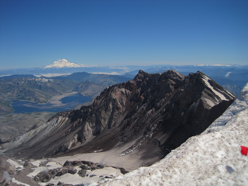
The above picture taken from Mt St Helens in July 2010. Mt Rainier is seen in the distance, about 50 miles north.
Labels:
A to Z,
Mt Rainier,
Mt St Helens,
Osceola mud flow,
volcano,
Washington nature
Tuesday, May 18, 2010
Happy Anniversary, Old Girl
In Native lore Mt St Helens is a woman, Loowit.


You hike starts in the woods at sunrise. Here you are just exiting and getting a look at the land to the west.

And begin climbing


Like I said, the clouds come and go
Dome and steam


True summit

Proof

The easy way down

She was fought over by Wyeast (Mt Hood)
and Klickitat / Pahto (Mt Adams)
Stories of these two rivals throwing fire and rocks at each other certainly tells of the geologic history of the area. In the book I, have Mt St Helens is the beautiful maiden who didn't act up.
A hole in the stories, since she certainly did and still does.
My pictures from July 2007
You hike starts in the woods at sunrise. Here you are just exiting and getting a look at the land to the west.
And begin climbing
And stopping to see where you have been. A good picture of new flows from 1980
The clouds come and go quickly here
The last 300 yards are like steep sand dunes
Like I said, the clouds come and go
Dome and steam
The west wall with the last of the ice
True summit

Proof

Mt Rainier about 50 miles north. Peek a boo visit
The easy way down

Ash everywhere
Thisw is the video I remember the most. This clip is from a broadcast 5 years ago with some footage I did not see in the original broadcast.
www.youtube.com/watch?v=njV9ski1gB4
and from NASA
Subscribe to:
Posts (Atom)