Ramblings around Washington State. Natural wonders of my world. I am forever trying to learn. Strong caution, pictures of plants may include bugs,spiders and other "creepy" things. Natural history plants flowers bugs birds biologies. Geology weather conservation and gentle hikes.
About Me
- Upupaepops
- Just a meandering soul sharing my backyard. Visit my Flickr page too! www.flickr.com/photos/meanderingwa/
Showing posts with label Redwood Sorrel. Show all posts
Monday, March 17, 2014
A Wee Bit - o - Green
Redwood Sorrel , Oxalis oregana
These happy under-story plants are starting back now, with flowers on the way. In the normal, dark under-story these leaves are held flat, but in bright sunlight and at night they can fold down as you can see here.
They also fold down in heavy rain downpours.
We had that this weekend for sure.
Labels:
Oxalis oregana,
Redwood Sorrel,
Washington nature
Location:
Thurston County, WA, USA
Thursday, August 11, 2011
Tootling Along the Toutle
Last weekend I joined the Nisqually Land trust on a walk about one of its properties. It was nice to visit a property I had not yet visited.
I immediately noticed the abundance of Redwood Sorel also known as Oxalis. They were past bloom but their bobbing shamrock-like leaves are enchanting. They carpeted the woodland floor.
Beavers have moved in and their handy work is quite noticeable. The large beaver pond and water diversion fills the area. The Vine Maple in this picture is changing color already. It may be due to the excess moisture and perhaps the tannins usually associated with Red Cedar.
Most likely these Beaver are not chewing on the bark of the cedars for food as much as they may be using the fibrous bark for filling chinks in their timber home.
Everyone has their own area of interest. While many are looking up, I always have an eye for that close at hand.
This moth gave me a great photo-op. I was able to identify it as a Pale Beauty , Campaea perlata. One the underside of this leaf there was a second moth. I think we interrupted some important business.
Our leaders discussed the river and its powers. Every year people get into trouble with this river and its currents. While these rapids do not appear sever by river running standards.Along much of this rivers length log jams, snags and under-currents makes this river quite dangerous. On this day one local was doing a bit of fishing and retriever training with his fine dog.
Since it was Seafair Weekend, I thought long and hard about were I wanted to be, and more than that where I did not want to be. I decided to drive south and spend the night in Kelso so I could visit Johnson Ridge Center early in the morning. What an excellent choice.
I have not been to this area in many years. While I have been to the south side of the mountain for climbing, I have neglected the north side. The visitor center and all of its nice exhibits were behind locked doors, but I needed the early hours for my best enjoyment and to be back on the road before noon.
The drive up was wonderful. As I gained elevation I got peek-a-boo glimpses of the Toutle River valley. This valley took the brunt of the runoff flooding and destruction in 1980. Indeed the flood waters and debris almost over topped the I-5 bridge. Today from the freeway you can seen huge piles of mud debris dredged from the Toutle and Columbia rivers . The local community has gained a new recreation area from the leavings.
It was a heavy gray overcast morning in the lowlands and as I passed into a huge fog / cloud bank on the way up I wondered if I was going to be skunked. But as quickly as the fog bank enveloped me, I gained enough altitude to come out on the upper side with mixed clouds and sun.
This is the view up the valley through the area known as The Hummocks. You can see the Toutle River cutting its way through the mud flow. The biggest change from when I was last here, aside from the dome inside the crater, is that the dominant color is green.
Johnson Ridge is named after Dave Johnson's, a Geologist sitting watch who famously reported "Vancouver Vancouver This is it!" as he witnessed the eruption which took his and 56 other lives. The Visitors Center sits directly across from the crater opening and right on the edge giving you the view across the devastation and rebuilding.
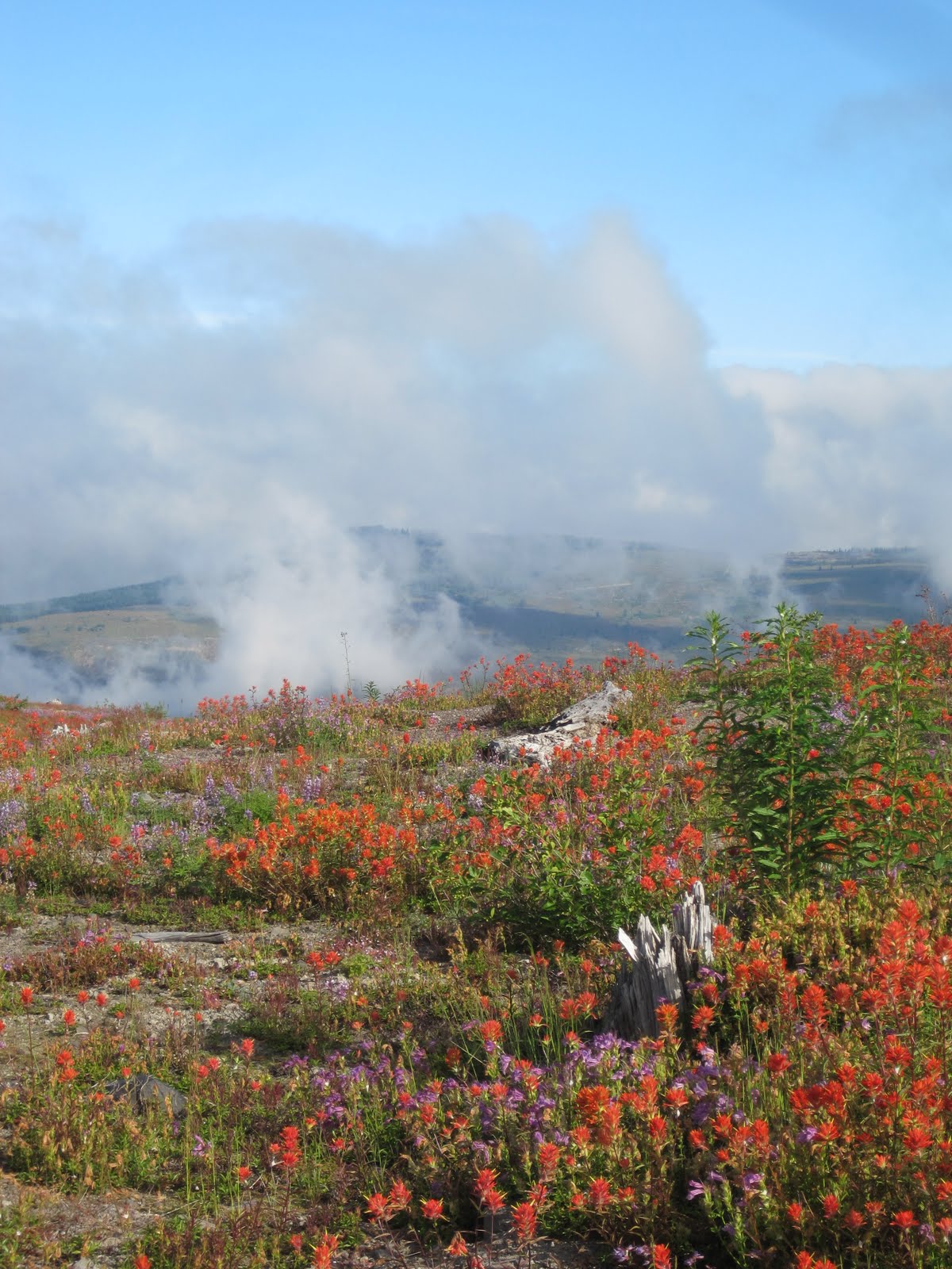
I wandered about enjoying the solitude and the lovely examples of early vegetation. These flowers have repopulated naturally. The whole monument is one large science lab of discovery. Blasted stumps show the force and power.
Dominant flowers are Indian Paintbrush ( red) Lupins ( blue) and Cardwells Penstemon
This bare slope certainly gives you a lot of information. The remaining logs show you the direction of the blast. The ruts show you where downed trees, since rotted away have left impressions further channeling water to groove the soil.
On a north facing slope these odd mushrooms are likely thriving on log buried, rotting wood.
To the north and east the Coldwater Ridge shows the effect of loss of trees, the addition of the ashy layer and the odd pattern of runoff scars.
The eruption created, and destroyed, several lakes. Coldwater Lake has become a popular fishing destination. The boardwalk out onto the lake shows water as clear as glass. The fishermen in their little boats were not in a chatty mood. I wanted to ask about the clarity further out.
I was happy to be able to capture one oddity, which showed up well on my picture. In 1983 many of the hills surrounding the monument were replanted with Nobel Fir. This has led to an odd and interesting effect. The trees are monoculture, all from nursery stock and all highly uniform. The visual effect is some odd double vision blurring. Look closely, each one uniform and so like the next. I suspect before long, storms and time will take their toll and other trees will creep in and get hold. Will this land eventually be harvested , or was it determined that this tree species is the one most likely to do well in this unique soil system. I really don't know.
The Wikipedia entry for Mt St Helen's is well done. There are lots of good links and photos. Please pay a visit.
http://en.wikipedia.org/wiki/Mount_St._Helens
I hit the road home early. I-5 northbound especially between Olympia and Seattle is MISERABLE on Sundays. No matter what happy times you had in the day, the traffic is sure to harsh that happy. I decided that I would take the back road, Hwy 507 from Centrallia to Puyallup then up the Valley Freeway to Hwy 18 . Cut over to North Bend and get home via the backdoor.
At noon I got to the coffee stand in Centrallia, where the young barista (and former commuter to Tacoma for college, poor kid) approved of my plan. I heard on the radio that traffic was already backed up at the Nisqually River.
By the time I got to the backside of Joint Base Lewis and McCord the I-5 Freeway backup was about 8 miles...then 10 miles. I shook my head in pity over those folks and smiled at my good plan. I knew the core of Seattle was no better with the I-90 bridge closed and people out enjoying the rare perfect 75 and sunny day.
I got to North Bend in three hours!!! That is a huge record for this drive and I will use this back road to happily meander home when I am in the south and west
Sunday, September 19, 2010
Nisqually Land Trust ~ Mt. Rainier Gateway
Saturday I joined the Nisqually Land Trust in what is the first volunteer event of the new 2010-11 work party season. I wrote about several events I attended over the last year and we are off on a new season of working in the great outdoors, no matter the weather.
The forecasts for this weekend were nothing to be happy about. It seemed doom and gloom but the reality was not that bad. I was fully prepared to get soaked through and went prepared with a full change of clothes. We had, however, the most glorious morning. It did in fact get downright hot while working. Mind you we had pretty much full sun and digging and whacking is hard work.
The property is one I had not been to before, The "Allen Estate" on the east edge of Ashford, right at the Mt Rainier NP gateway. www.nisquallylanddtrust.org/mtrainier/php
I had not been this far up the road in so very long. This property is that of the historic homestead of Oscar Dana Allen. Mr Allen was a contemporary of Gifford Pinchot who was the first chief of the US Forest Service and coined the term "Conservation Ethic". Along with his sons , Mr Allen made the first botanical assay of the park. He and his sons went on to be key in the administration of the park and state forests in the early half of the 1900's
My drive took me through the Ohop valley where last Halloween we had a work party to plant the valley floor. I stopped along the way to take a picture. While you might not be able to tell, I can see the green shrubs and trees we planted, hiding amid the tall grasses that have since sprung back up. There will be another Halloween work party this year and you can bet I will try to attend. You can see the photos from last years event in my 10/31/2009 blog entry.


Recycled Spirits of Iron by Dan Klennert


The rough grass needs to be whacked back and the turf and soil removed, the hard part. Dig and plant, the easy part. Well the easy part was based on where you dug. Clearly there was a large rock topped drive under this spot. From the state highway we drove up what once was an access road. Joe's truck created a perfume of "mint" as he drove over the greenery that carpeted this path through the woods. The only native mint I know of is Self Heal. I have never crushed it to see if it smells as lovely as this. The open area was overgrown with native blackberry, nettle and non native Scots Broom. Hidden was where the access lane continued on. Shovels found it in the form of rough egg sized rocks covered over by soil.

Sun Mountain


Nisqually Glacier
The forecasts for this weekend were nothing to be happy about. It seemed doom and gloom but the reality was not that bad. I was fully prepared to get soaked through and went prepared with a full change of clothes. We had, however, the most glorious morning. It did in fact get downright hot while working. Mind you we had pretty much full sun and digging and whacking is hard work.
The property is one I had not been to before, The "Allen Estate" on the east edge of Ashford, right at the Mt Rainier NP gateway. www.nisquallylanddtrust.org/mtrainier/php
I had not been this far up the road in so very long. This property is that of the historic homestead of Oscar Dana Allen. Mr Allen was a contemporary of Gifford Pinchot who was the first chief of the US Forest Service and coined the term "Conservation Ethic". Along with his sons , Mr Allen made the first botanical assay of the park. He and his sons went on to be key in the administration of the park and state forests in the early half of the 1900's
My drive took me through the Ohop valley where last Halloween we had a work party to plant the valley floor. I stopped along the way to take a picture. While you might not be able to tell, I can see the green shrubs and trees we planted, hiding amid the tall grasses that have since sprung back up. There will be another Halloween work party this year and you can bet I will try to attend. You can see the photos from last years event in my 10/31/2009 blog entry.
I passed wood art and metal art. Recycled Spirits of Iron by Dan Klennert is a fun stop along the way. There is also an excellent coffee stop at the Ashford HQ of International Mountain Guides. After working I stopped at Copper Creek Inn, near the park gate for an excellent bowl of stew.
Recycled Spirits of Iron by Dan Klennert
This work party was a two-part. Start by pulling out Scots Broom ( yippee violence mayhem and destruction) and then plant Douglas Fir trees. The Scots Broom pull is made easy with root jacks and plenty of hands. Our little group made short work and then got on to the trees. They were beautiful! One volunteer had nurtured them through the summer and she reports they had easily doubled in their size. Every pot, tree and hour spent in raising these trees along with the greenhouse space at Pack Forest was donated. A labor of love.
Look at these little darlings. Classic Christmas trees that will grow to be our regions iconic tree. The green tapes will make them easy to spot while they are little.
As usual, Joe Kennedy gave a demo on how to properly plant the trees.
The rough grass needs to be whacked back and the turf and soil removed, the hard part. Dig and plant, the easy part. Well the easy part was based on where you dug. Clearly there was a large rock topped drive under this spot. From the state highway we drove up what once was an access road. Joe's truck created a perfume of "mint" as he drove over the greenery that carpeted this path through the woods. The only native mint I know of is Self Heal. I have never crushed it to see if it smells as lovely as this. The open area was overgrown with native blackberry, nettle and non native Scots Broom. Hidden was where the access lane continued on. Shovels found it in the form of rough egg sized rocks covered over by soil.
We cleared the area of broom and planted 100 trees in three hours. There was time for a chat break where we learned about the property and of the long term effort in this area. The preservation of blocks of habitat provides for all of the animals and flora with particular attention of the habitat needed for Spotted Owl and Marbled Murrelet. The murrelet is a seabird which nests in the forest. They will fly out to the Pacific Ocean and back to this area EVERY DAY during nest season. That is about 125 miles one way. I have only ever seen murrelet on the ocean, never in the woods.
After work and a bit of lunch, I decided since I was all the way up here, I might as well go home the "pretty way". So I entered Mt Rainier NP and circled around via Paradise. I used to drive this road every summer when I lived further south from Seattle. Now it is much easier to access the park from the Sunrise area. I love this road from Longmire to Paradise as it is very wild. Much as it was in the early part of the 1900's it is two lanes almost no shoulder. Giant trees edge right up to the road much like the Hoh Rainforest Road. Every so often you see where one of these close trees have taken whacks from wide load motor homes. I have to imagine there are a lot of motor homes who have lost their passenger side mirrors. Deep scars about mirror high mark these trunks.
I stopped along the way at different points just to enjoy the sights. Mt Rainier creates it own weather and I went from the sunny clear miracle morning to a totally socked in mountain in about 40 minutes.
Sun Mountain
I love seeing evidence of the historic CCC work crew constructions. Tunnels and stone bridges in particular. The view area for Christine Falls allows you to see the lovely stonework.
Box Canyon a 180 foot deep gouge made by the Muddy Fork Cowlitz River has a wonderful tunnel on its west side. Along the trail you can see the glacier carved stone that makes up this canyon and its walls. Here it is simply stone covered by moss and lichens.
I did find some evidence of late summers bloom but for the most part they are gone and now the hillsides are hues of yellow and gold with occasional Mountain and Vine Maple trees adding their color.
Paintbrush and Pearly everlasting.
An Earth Star type, Geastrum sp. puffball
Lovely Redwood Sorrel
The Nisqually Land trust takes its name for the beautiful river that carved this territory and the people who call it their homeland. The Nisqually River starts at the foot of Nisqually Glacier a sadly reduced glacier but never the less powerful to experience. I have been up on the trials above the glacier and you can hear sounds in the mists that tell you there is a power deep in this river of ice.
The young river in its glacial valley
Nisqually Glacier
Subscribe to:
Posts (Atom)